
Page 6 - Sept-Oct2023 Vol 41 No 3
P. 6
RED BANK By John Chlarson, P.E.
Multiple Entities Collaborate
on Pavement, Accident Study
This article discusses a traffic and
pavement field study conducted by
the UT Municipal Technical Advisory
Service (MTAS) in cooperation with the
UT Center for Transportation Research
(CTR), and the University of Tennessee
Knoxville’s Department of Civil and
Environmental Engineering (CEE).
Assistance was originally requested
by Chief Dan Seymour with the City of
Red Bank Police Department. Seymour
wrote he was looking “at three to four
(Red Bank) locations to complete traffic
studies for the purpose of exploring the
use of speed cameras to address speeding
complaints and crashes.”
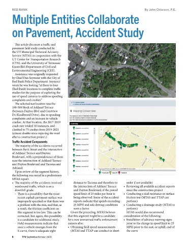
The selected test location was the
100‐500 block of Ashland Terrace
(between Dayton Blvd and Crestview
Dr./Knollwood Drive), due to speeding
complaints and an increase in vehicle
crashes. At that location, the 2017-2019
crash rate totaled 30 instances, and
climbed to 75 crashes from 2019-2021
(almost double since repaving the road
after a construction project.)
Traffic Accident Components
The majority of the accidents occurred
between Bank Street and the intersection
of Ashland Terrace and Dayton
Boulevard, with a preponderance of them
near the intersection of Ashland Terrace
and Dayton Boulevard and Tacoma and
Ashland.
Upon review of the segment history,
the following was noted in a preliminary
MTAS report:
• The majority of the accidents involved distance to Tacoma and therefore to order if not available)
westbound traffic, which is on a the intersection of Ashland Terrace • Reviewing all available accident reports
downhill grade. and Dayton Boulevard, if the posted since the construction project
- There is a possibility that the most speed limit of 25 miles per hour is • Conducting a skid resistance or surface
recent asphalt pavement surface was being observed. Some of the accident friction test (MTAS and TTAP can
improperly specified or that there was reports indicate that speeds exceeding perform)
a problem with the mix, and that, as 25 MPH and safe driving conditions • Conducting a drainage study (MTAS to
a result, the friction coefficient on were a factor. perform)
this segment is too low. This can be Given the preceding, MTAS believes MTAS would also recommend
corrected, but, again, this possibility that this segment might be a candidate consideration of the following:
is a candidate for additional study. for a new unmanned traffic enforcement • Installation of advance warning signs
- Field measurements indicate that camera after: prior to the change in speed limit to 25
once a vehicle emerges from the • Obtaining field speed measurements MPH prior to the east, or uphill, end of
S-curve, there is adequate sight (MTAS and TTAP can conduct in short the curve
6 TPW September/October 2023