
Page 7 - Nov-Dec18
P. 7
vehicles (UAVs) - otherwise known approximately 25 years and receives same area. Most importantly, volume
as drones - can be an even greater solid waste from all of Hamblen calculations performed between the two
resource for landfill managers. UAVs County and many other surrounding flights nearly matched the volume of the
can be used to help landfill operators communities. A DJ1 Phantom 4 Pro weight calculated at the landfill scales.
maximize airspace, assess slope stability was used to conduct the two flights and
and monitor their facilities’ operations gather the imagery. The conclusions of the research
for erosion, standing liquids and hot were compelling and will be beneficial
spots. Currently, this information is We found that surveying from the to future operations of Hamblen
gathered by ground surveying methods. air provided more efficient and accurate County and other landfills. Utilizing
It’s done on foot and over rough topographical and volume data than UAVs provides a safer data collection
terrain. Using a UAV and structure conventional surveying. The accuracy environment, more accurate and timely
from motion (SfM) techniques offers a of the data was nearly identical to data, and will reduce overall operating
better alternative to capture that data by LiDAR bare earth data collected in the costs.
providing a less labor-intensive, more
accurate depiction of the topography. Class IV Sub-Grade
SfM is a photogrammetric imaging
technique that is used to estimate
three-dimensional structures from
two-dimensional images that creates an
accurate model.
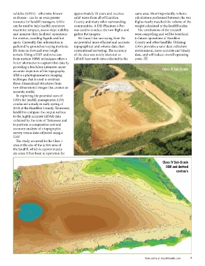
In exploring the potential uses of
UAVs for landfill management, LDA
conducted a study in early spring of
2018 at the Hamblen County, Tennessee,
landfill to compare the output surface
to the highly accurate LiDAR data
collected by the state of Tennessee and
to perform a comparative cost and
accuracy analysis of a topographic
survey versus data collected using a
UAV.
The study occurred in the Class 1
area at the site of the active area of
the landfill, which is approximately
six acres. It has been in operation for
Class IV Sub-Grade
DEM and derived
contours
View online at tnpublicworks.com 7