
Page 11 - March-April2021 Vol 38 No 7
P. 11
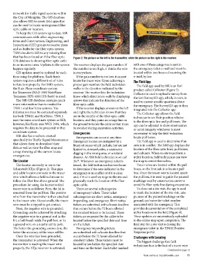
network for traffic signal systems within     Figure 2. The picture on the left is the transmitter, while the picture on the right is the receiver.
the City of Memphis. The GIS database
also allows SSR to create field apps that     The receiver displays the gain number. If         with one of these categories is sent to
can be used to locate underground fiber       the number is too high, it thinks the wire        the emergency ticket e-mail and must be
optic cable on location.                      is everywhere.                                    located within two hours of receiving the
                                                                                                e-mail, by law.
  To keep the GIS system up to date, SSR        If the gain number is too low, it cannot
communicates with other engineering           locate the tracer wire. Upon achieving a          The Field App
firms and Construction, Engineering, and      proper gain number, the field technician            The field app used by SSR is an Esri
Inspections (CEI) groups to receive plans     walks in the direction indicated by the
and as-builts for the fiber optic system.     receiver. The receiver lets the technician        product called Collector (Figure 3).
TSM also alerts SSR to any missing fiber      know which direction to walk by displaying        Collector is used to upload a survey from
that has been found or if the fiber optic     arrows that indicate the direction of the         the Esri Survey123 app, which, in turn, is
GIS database is showing fiber optic cable     fiber optic cable.                                used to answer specific questions about
in an incorrect area. Updates to the system                                                     the emergency. The Survey123 app is then
happen regularly.                               If the receiver displays arrows on the left     integrated into the Collector app.
                                              and right, the technician knows that they
  GIS updates must be updated for each        are in the middle of the fiber optic cable          The Collector app allows the field
firm using the platform. Each firm’s          location, and they paint an orange line on        technician to see their position relative
system requires a different set of rules      the ground to locate the cable so that it can     to the fiber optic line and pull boxes. The
to function properly. For SSR’s system,       be avoided during excavation activities.          app can be adjusted to show street names
the State Plane coordinate system             Emergencies                                       or aerial imagery, whichever is most
for Tennessee (NAD 1983 StatePlane                                                              convenient to help the field technician
Tennessee FIPS 4100 (US Feet)) is used.         Emergencies can occur at any time.              locate pull boxes.
                                              Emergency locates are instigated by a
  The SSR GIS database contains much          litany of causes which include, but are not         The field app is used to determine if an
more information than is needed for           limited to, downed poles, a contractor            area is in conflict. The field app displays the
TN811 and KorTerra systems. The               digging in the wrong area, or a natural           location of the fiber optic lines, pull boxes,
information must be extracted separately      disaster. An SSR field technician is on call      and cabinets. When on site to perform a
for both TN811 and KorTerra. TN811            24/7. Whenever an emergency ticket is             utility location, field technicians can view
uses the same coordinate system as SSR;       issued, the field technician has two hours        the map to orient themselves.
however, KorTerra uses WGS 1984, which        to determine if the area indicated in the
requires the data to be projected to that     emergency is in conflict or if it is clear,         Tracer wires are located within the pull
coordinate system.                            and, if it is in conflict, to go to the site and  boxes, so the first task is to locate a pull
                                              physically mark the location of the fiber         box. Once the tracer wire is located inside
  SSR also has a website created              optic cable.                                      the pull box, it is used to guide the painted
specifically for Traffic Signal Maintenance                                                     markings used by construction crews to
that allows them to download their              There are several subcategories                 avoid the fiber optic line during excavation.
data as well as view the fiber map and        of emergency tickets. These ticket
a map showing all the current locate          subcategories are short notice, emergency           To close out a site visit, the app is used
emergencies.                                  impending, and emergency. Short notice            to mark the location of the site visit, take
The Locator                                   tickets are submitted with a locate deadline      pictures of the painted markings on the
                                              that occurs before the 72 hours allotted          ground, and enter the ticket number
  The locator currently in use is the         for standard tickets to be located. These         associated with the emergency. This
Schonstedt XTpc (Figure 2). This pipe         tickets are requested by the caller to be         provides documentation of the completed
and cable locator connects to the tracer      located before the specified date and time        utility locations in the field (Figure 4).
wire which allows a field technician to       on the ticket.                                    These updates are automatically uploaded
follow the fiber line above ground. The                                                         to the online map upon completion. The
procedure for using the locator to find         Emergency impending tickets                     final step for a site visit is closing the
tracer wire is as follows: First, the lid is  are submitted with a locate deadline that         emergency ticket in the TN811 Positive
removed from the pull box. The positive       occurs before the 72 hours allotted for           Response portal.
wire from the transmitter is then attached    standard tickets. These tickets must be
to the tracer wire. Occasionally, the tracer  located by law before the specified date          Challenges with Locating
wire must be stripped to get contact.         and time on the ticket. Each ticket marked          The biggest challenge that field

  Next, the negative wire is grounded.                                                	         technicians face is the lack of a tracer wire
Grounding can be achieved by attaching
the negative wire to a ground rod in the                                                        Continued on page 12
kit, a bolt head inside the pull box, or to
a ground wire on a nearby utility pole.
The better the grounding connection, the
better the accuracy of the trace will be.

  Once the wire has been grounded,
the transmitter is activated. When the
transmitter is reading the tracer wire
properly, the XTpc receiver is activated.

                                                                                                View online at tnpublicworks.com	                    11